The Mellonkoski nature trail (3 km) starts right next to Imatran Valtionhotelli (Imatra State Hotel) which was built in 1903, financed by Finnish Senate. The architect
Usko Nyström must have had fun designing the jugend style building with its stylish details. I've never dared to count how many different window shapes there are! I spend a while studying the nature trail map at the Kruununpuisto park before setting off; I left the trail map leaflet (borrowed from the city library) behind. It is best to take a snapshot of the route so that if necessary, I can check it from my camera to make sure I won't take a wrong turn. At the start, I can't fail however, so a lazy stroll round the impressive hotel building is a good way to start my walk.
Nature is present on the stone walls of the castle-like building, but also in the cute hand-crafted image on the wall, next to the main entrance to the hotel: this must depict the start of the Imatrankoski rapids when the water still ran wild next to the hotel.
The Imatrankoski rapids with its dry riverbed is a strange sight, revealing the harsh rocky bottom. The large dam behind the bridge was built for the hydroelectric plant which made the Vuoksi river even more useful for man but gone was the free-roaming water; Imatrankoski rapids was history. In the summertime the floodgate is however opened daily for the tourists for about 20 minutes and you can get an idea of what the rapids used to be like.
Walking down by the riverbank, you can see lots of engravings on the rocks - better slow down to read at least some of them, because there is history. The ancient graffiti displayes memories of visits by both ordinary people (I suppose so at least) and monarchs who all visited the area to admire the famous rapids.
Pedro II, the king of Brazil, came over with only three companions in 1876, but the most famous visitor was probably the Russian empress
Catherine the Great who came down with her large entourage in 1772.
The sun catches me by surprise when I'm at the simple pavilion by the riverbank. In November, such light feels rare in Finland because the days are getting shorter and shorter...
The trail passes an empty outdoor theatre venue - in use during the busiest summer months only - and descends closer to the water. Vuoksi river now follows the canal next door built for the hydroelectric plant and it is as if the river is trying to reach its former route from this direction. In vain.
The trail is marked with blue paint and numbered cone symbols and it is pretty easy to follow. I gather that the moss-covered rocks on the side of the narrow road must have been at the bottom of the ancient Vuoksi riverbed.
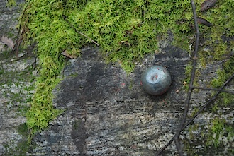
When I pass a large rock on the left, next to the Vuoksi river, I notice a small metal "button" on it. What on earth could this be?
The trail takes me to a dyke way which these days connects some small islands and allows you to cross to the other side of Mellonlahti bay. The pier with its four wooden tables is used for washing rugs when the water is somewhat warmer than now... like in the summer months. However, these days such washing places are being moved on the shore more and more, to prevent the fish getting soap in their eyes. Better for the environment that way. Otherwise, the tradition of scrubbing your rugs clean outdoors is simply great!
I arrive at the other side of the Mellonlahti bay and turn back to follow the nature trail. Vuoksi river runs on my right, and Mellonlahti bay, now separated from Vuoksi by the dyke road, is on the left. In Mellonlahti bay, fishing is forbidden, but I see a solitary fisherman on a small boat to my right.
On my return I turn to the left to the wooden pedestrian bridge which takes me to Kuukansaari which used to be a proper island before the dyke road was built. Unfortunately I haven't carried logs with me to make a campfire at the shelter (it's an absolute NO to take firewood from the forest!), so it's better to keep moving along the narrow, winding paths to get back to the nature trail on the other side of Kuukansaari.
The nature trail turns to the left and shows Mellonlahti bay in the bluish afternoon light, almost asleep. A man is turning his rowing boat upside down for the winter, and I go to him to ask if he needs help. - Oh no, I'll manage, he says, and shouts thanks for the offer when I turn away. Twenty seconds later I hear a thump. The boat has turned back to its original position. Oh well, I did offer...
On the right, a row of tall spruces at the top of the ridge guards the path. I climb up the trail, then take the wooden steps down to the shore and wonder why the arrows pointed this way. As I look into the shallow water, I notice continuously bursting bubbles here and there: tiny natural springs. The brook is nearly dry, but water comes from underground.
The path soon leaves the forest and meets an asphalt road. On the right, you can see Mellonmäki hill which is the end of the trail, so it is quite easy to find your way there. After crossing the road, the blue trail marks appear again, and the trail turns left before winding its way to the very top of Mellonmäki.
Mellonmäki is about 108 metres high, but you can climb even higher if you go up the wooden ski jump tower. The smoke in the distance comes from
Svetogorsk, Russia - from one of the biggest paper mills in the whole country. I am indeed very, very close to the Russian border. Svetogorsk has a Finnish history; the town was originally called Enso (part of Jääski) and it was part of Finland until taken over by the Soviet Union in World War II.
Looking over the border area at Russia from here, I see only a huge, never-ending forest in late autumn colours. Seen from this ski-jump tower, it looks like a quiet neighbour. I feel the wind in my ears and take a stronger grip of the rail. Time to descend from the slightly swaying (or am I just imagining?) tower and the Mellonmäki hill back towards the town. The narrow path takes me down to the road and it's easy to figure out that by turning to the left I will easily get back to where I started, at Valtionhotelli Hotel and its park.
I am already very close to Valtionhotelli hotel when I see an square rock by the side of the road on the right.
As I step closer, I realise that it is an old boundary mark: the engravings say
Ruokolahti and
Joutseno. Ruokolahti is still an independent commune, but Joutseno is these days part of Lappeenranta city. Ruokolahti and Joutseno both contributed land to Imatra when the town was born in 1948 after World War II, on the ruins of the large Jääski commune which mostly remained on the eastern side of the border of Finland and Russia. Glad to see this landmark is still there, reminding Imatra of its history.
For a November walk, this nature trail may not offer spectacular views and colours, but the route combines both nature and man-made landmarks and at least gives you a peek across the border to Russia.


No comments:
Post a Comment