Showing posts with label nature trail. Show all posts

Friday, 1 March 2013

Korpilahti: Vaarunvuoret nature trail

Vaarunvuoret nature trail or "Vaarunpolku" as it is called on the spot, can be found in Korpilahti, about 38 kilometres south from Jyväskylä in Central Finland. The site is located on a scenic route (road 610) between Korpilahti and Joutsa, not very far from Kärkinen bridge that crosses Finland's second biggest lake, Päijänne.
The footprints before me show me the way but I still prefer to wear my snowshoes - it will be so much easier to step aside when I wish plus you never know how far the previous walkers have gone along the 4 kilometre long trail. As usual, the beaty of the white forest descends upon me like snow flakes, gently, slowly, softly.
V for Vaarunvuoret. Spruces, pines, a swamp, and finally a small lake surrounded by junipers: Särkijärvi. On the other side of the lake there is the only campfire site in this nature reserve - you simply aren't allowed to make a fire anywhere else.
On the other hand, it is a bit too early on that I arrive at the campfire site... Yes, there would be plenty of firewood available at the old-fashioned shed but I'm not quite yet in the mood for having a snack. The scenic spot (Vaarunvuoret is literally "Vaaru Hills") is only 0.6 km away but I feel like walking a bit more. However, there is a side track to Korospohja by lake Päijänne - great!
The track to Korospohja goes downhill all the way and is amazingly straight. The explanation behind it is that before it became part of the hiking trail it was an official road until the 1980's, connecting Luhanka and Korpilahti. The Vanha Vaaruntie road was famous for its steepness and it slowly dawns on me that yes, I do have to walk back uphill! Just imagine a bus driving slowly uphill, with passengers stepping out and perhaps pushing the bus...That was also reality sometimes!
Those who visit Vaarunvuoret area by boat step ashore right here, at Korospohjanlahti bay on the eastern shore of lake Päijänne. Standing here you can't really see that there's a steep hill very close by so I have to walk a bit further to the steepest part, Vaarunjyrkkä, to get some idea.
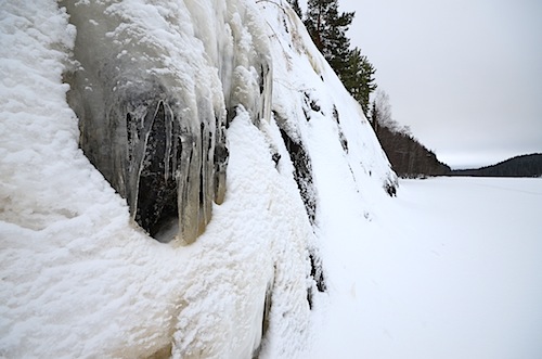
After about a kilometre's walk on the ice I arrive at Vaarunjyrkkä's rocky shore. On such a grey day as this and with the rocky hill covered with snow it doesn't look as spectacular as you might expect. However, I can easily imagine how great this all looks in the summer, with bright blue skyes above and the light waves of lake Päijänne splashing against the granite.
There's always something special to see though: at least some artistic icicles. When I start my return journey to the nature trail via Korospohja, I foolishly change my route on the ice and after a short while realize how heavy my snowshoes have just become. Below the layer of snow, there is already water on the frozen lake - and it means that the slush starts to stick to the bottom of my snowshoes and they're becoming ice shoes. For a second. Until I scrape the ice off them and head quickly as close to the shore as possible and find a better route. It seems that the best season for walking on the ice is now almost over.
I have a short tea break at Korospohja before climbing back up along Vanha Vaaruntie road - a wise decision because it isn't exactly a light walk uphill - but when I arrive back at Särkijärvi campfire site I don't feel like stopping there for making a fire. Onwards! Up! Oh, how the last leg to the top feels so easy! And I'm once again back among the winter fairytale land.
The Vaarunvuori hill is pretty steep so I'm somewhat surprised to find some cross country skiing tracks heading downhill from the top, across the nature trail track. I truly hope all has gone well before the skiers have arrived at lake Päijänne, somewhere down there. There are so many trees there that it can't be too easy to avoid hitting them on the way.
Once I'm at the scenic spot, I get a better idea of how tall the Vaarunvuoret hills are - lake Päijänne is so much below me and you can see pretty far through the opening between the trees. The guest book that is hiding in the wooden box is already full and it is hard to find a place where to scribble my signature and there's no telling who was here last and when that was. Beware of the steep hill, says the sign - Varo jyrkännettä.

I am extremely happy to be wearing snow shoes, judging by the 'trail' which was made by someone who was simply wearing boots. He or she has stepped in pretty steep snow but has still managed to keep going!
The route marks (blue paint, in places yellow paint) lead me to an opening which is the only place where I can't locate the next trail sign. My own fault for not paying attention perhaps; here the route doesn't actually enter the opening (which is on private land) but goes round it, making a sharp turn to the right and then heading back to the woods. I take a minute to locate the trail again but while I do so, I pay a visit to the snow-covered Loch Päijänne Monster, nature's creation, that actually is looking exactly where the trail is...

Vaarunvuoret area can surely offer great experiences all year round, and definitely not just in the summer. Yet it would be pretty cool to arrive there on a kayak on a summer's day!

Monday, 11 February 2013

Laukaa: Multamäki nature trail

Multamäki nature trail can be found in Laukaa, close to Peurunkajärvi lake in Central Finland. The easiest route to the start of the trail is via Spa Hotel Peurunka (few kilometres north from Laukaa): drive past the spa hotel buildings and follow the road towards  Finninkylä and further until Multamäki. In the winter you may find the private road to Multamäki closed - and the nature trail (luontopolku) sign can be seen right next to the gate. If you are lucky, you may even be able to park by the side of the road - if there isn't too much snow!
I am equipped with snowshoes which proves to be a clever choice because although there is a snowmobile track at the start of the trail, it is made for cross country skiing and not for walking, and very soon we need to part anyway; the nature trail takes a sharp turn to the left and I see virgin snow ahead. The yellow trail signs lead me to the official start of the Multamäki nature trail with a map depicting the route. It seems that no one has stopped here for a snack for quite some time!
This seems to be one of the best marked nature trails in Jyväskylä area - thanks to Laukaa municipality which seems to take excellent care of such routes! 
As is typical on nature trails, there are quite a few signs with more information about nature along the way. However, the snowy weather has covered practically all of them and even if you brush the snow off, the text (in Finnish) is hardly legible because you'd need to scrape the ice off as well. I'm not in the mood for doing that with my woollen mittens! Also, typically these guides describe things that would be easiest to discover when there is no snow on the ground.
So, my walk in the forest is simply a pleasure walk, enjoying the beautiful scenery, the shapes covered with pure white snow, examining footprints and guessing who or what has gone past. Those could be the footprints of elks...
If I wasn't wearing snowshoes, I might be tempted to try a different route but now there's no stopping me. Straight ahead! Anyway, only few meters away I find a fresh trail of another snowshoe walker who makes my going even lighter in the powder snow. I climb up the hill and soon the nature trail again joins a wide trail made by a snowmobile. Careful... But there are no cross country skiers in sight.
Step by step I reach the very top of Multamäki hill, the highest point of the trail. Multamäki hill is part of the original so-called Struve Geodetic Arc (#46) which was measured and marked in the mid 19th century in different countries. There was a survey triangulation station for quite a long time but the last wooden station from 1980 is long gone; in its place is now the kota under which the original plaque still exists.
The view from Multamäki hill is lovely; I am now at 211.4 meters above sea level and lake Peurunkajärvi is about 105 meters below me. Besides the kota (which is the only place where you are allowed to make a fire here on top of the hill) there is also an open shelter for enjoying a snack outdoors. There are quite a few footprints on the snow so this seems to be a pretty popular place.
From the top of Multamäki hill, the nature trail continues down towards the lake, along long and steep wooden steps that are totally covered with snow. Should I take off my snowshoes? No way! I step off the steps and partly slide down the steep hill in the snow, falling down only once...This is so much fun!
When I get down to lake Peurunkajärvi I could even take off my snowshoes because there have been so many other visitors to the shelter - the path in the snow would be so easy to walk on. I can't see anyone skiing on the lake but there are a couple of ice fishermen!
I arrive at exactly the same time to the open shelter as one of the fishermen comes there for his break. Once again, I get to sit in front of a ready made fire and enjoy the moment with hot tea from my thermos flask. Another fisherman joins us and says a shy hello. The fishermen seem surprisingly quiet but soon I find out why: we don't share the same language. Unfortunately, I don't speak Russian so I can't ask whether they've had any luck fishing.
After the relaxing, quiet break by the lake I walk up the hill to finish the trail that goes past some tepees - a surprising sight in a Finnish forest but I suppose they are there for children's camps that are sometimes held at the nearby Multamäki recreation centre, owned by Laukaa municipality. After I've passed the Multamäki centre's buildings, the nature trail sign guides me to join the snowmobile track for the remaining 100-200 meters but I step off it, not wanting to leave my snow shoe prints on a trail that has been made for cross country skiing.

As usual, many trails that are used by walkers for 3/4 of the year when we don't have snow, turn into cross country skiing tracks in the winter. I try to avoid such tracks when I go for a walk and the best way to do it is to wear snowshoes which allow you to walk anywhere - but it may be frustrating if you see that the lovely, hard and wide track is unused when you are stepping deep in the snow. If you ski in the traditional style, there would be room for both skiers and walkers side by side on the track made by a snowmobile, but those who ski fast use ski skating technique which requires the full width of the wide track...  So, unless you are skiing yourself, it is best to stay off the skiing tracks whenever possible, and walk somewhere else.

Tuesday, 5 February 2013

Nyrölä nature trail in winter

Nyrölä is a small village about 20 kilometres northwest from Jyväskylä. It is best known for its Kallioplanetaario (Planetarium, open daily) but offers also a chance for a nice walk on the well-kept nature trail. On a winter's day  just the ride to Nyrölä is a joy: after leaving the town, the woods surrounding the roads are wearing their best winter robes. My only question is whether the Nyrölä nature trail is "open" in the winter as well. That is, have there been other walkers before me?
The whole circular trail is about 3 kilometres long but nobody seems to have walked the whole route recently; I can only see footprints in the direction of the Iso-Musta lake where the closest laavu shelter is. No problem! I've got snowshoes with me...
Whereas the snow may already have fallen on the ground in the city centre where it is somewhat warmer, there is plenty of the white stuff over here - and not just on the ground. I could easily make my walk shorter (and easier) by following the narrow road on which a snowmobile has made a track recently but when I see the snow-covered sign Luontopolku (nature trail) it is much more inviting. Snow, snow and more snow!
I enter the woods and start following the trail signs that mostly consist of yellow-topped wooden poles (originally haypoles) but there are also a couple of paint marks on the trees, probably made with reflective paint. Using that kind of paint is not a bad idea at all if you happen to be on the trail after dark.
If I wasn't wearing snowshoes my progress would be much slower! And if the trail wasn't so well marked it would be very easy not to know which way to go because you can't always tell which way the path, now totally covered with snow, is turning. The only other footprints I discover between these trees belong to small animals.
I can still remember what it looked like in here on my last visit to Nyrölä nature path; so different, so green. Behind these trees there is a small man-made pond which was dug in a place where there was a natural spring. A recent local newspaper article revealed that the name Nyrölä originates from the word nyry (nira) which means a small trail of water, according to the writer Ilmari Kosonen.
The trail leaves the forest and I am again surrounded by open space. I turn to look to my right. The snow and frost covered trees are simply stunning - like a graphic illustration, almost surreal in its beauty.
Locating the haypoles and a dash of yellow paint isn't always too easy... The nature sometimes plays tricks on you. I find a couple of them but then... Nothing. However, I know the trail is supposed to meet the narrow road right ahead and it takes only a minute or two to be back on track.
Somebody's been busy felling trees! There is a huge pile of firewood waiting to be collected by the side of the road. I continue walking uphill along the snowmobile trail and remember the gorgeous green moss below the fir trees on a certain October day more than a year ago.
I know most people enjoy the Finnish winter on skis but snowshoes are my favourite. Although the snowmobile has made walking here even easier, we go different ways from the top of the hill and I get to walk downhill on virgin snow, making my very own path. I just love it!
The dense spruce forest has an almost eerie atmosphere and again I feel I'm watching a graphic illustration.
Time for a break? This beautiful lean-to offers a chance to make a fire and sit under the shelter, no matter the weather. The last time I was here it was almost ready for use but not quite. This would be a great place for star-gazing on a clear night, with the open sky above and no street lights disturbing the view.
However, I decide to walk just a bit further. Within a short distance, on the other side of the bog, there is the Iso-Musta lake and the small island where there is another shelter. No need to use the tiny ferry to cross the lake now that the lake is frozen... Do I smell smoke?
Oh yes! The group of people that I just saw leaving the island had a fire going and the embers are still there, burning hot. It only takes a couple of puffs to get the fire going again. Time to sit down by the fire and have a cup of hot tea from a kuksa, a traditional cup made of wood, and some pulla (a bun). What a great day!
From Iso-Musta the circular trail continues back towards the parking lot, following first a path and then a wider trail. The remaining 1.2 kilometres offer more of beautiful winter scenery now that the felled area is covered with snow.
The young birch creates an arch above the trail, thanks to the weight of the snow. The poor tree will straighten her back after the snow has melted. The path is now pretty firm under my feet; so firm that I take off my snowshoes and walk the rest of the way carrying them in my hands. You don't always need to have clear blue skies for the day to be beautiful; black and white can be equally gorgeous.

Wednesday, 2 January 2013

Saarijärvi: Winter at Kulhanvuori

What a glorious winter day! I can't resist the call of the bright sunlight and the snow but drive about 90 kilometers northwest from Jyväskylä to a beautiful, quiet corner of Central Finland: my destination is Kulhanvuori area at Saarijärvi. The wooden signpost at Konttimäentie road is covered with frost and snow but it is legible enough: Kulhanvuori it is. I park the car by the side of the road and walk along the narrow trail made by the previous visitors; the last bit of road that leads to the car park hasn't seen a snow plough this season. The nature reserve welcomes me after about 1.5 km walk.
Of course, I could have worn or even taken my snow shoes with me... But I half forgot them in the car when I saw the trail leading to the nature reserve. Plus there isn't that much snow, really. Only about 20-30 cm in most places. Nevertheless, I trust my instinct and follow the trail made by the previous visitors - surely they've followed the nature trail as well? At least they've made a fire by the Iso-Musta lake although there isnt' that much firewood left for hikers right now.
Looking at the frozen lake, I see only the happily circling footprints of the people who've been here before me. Perhaps today, perhaps yesterday, or the day before. Suddenly the sky changes colour, and the sun almost disappears behind mist that looks like it is trying to choke the source of light. The tricks that cold weather plays - it is so hard to believe that it isn't late afternoon but this it is hardly after mid-day.
The path by Iso-Musta lake is surrounded by the magical, dimmed light of this strangely beautiful winter day. Come to think of it, I could stop here and make a fire and just enjoy the magic, but the call of the trail is far too loud. Let's see where the path will take me.
The marked nature trail turns right at the partly frozen brook that leads from Iso-Musta lake to its smaller sister, Pieni-Musta lake. However, this is also where the footprints end and I have to decide whether to keep going - without snow shoes - or turn back. After a moment's thought I turn my eyes to the trail marks. If the trail seems to be marked well enough, I'll trample in the snow and do the nature trail. If at some point it doesn't seem like a good idea anymore, I can always turn back. Anyway, I am wearing gaiters so snow won't get into my hiking boots.
I breath in the crisp air, the scenery powdered in white. It doesn't feel cold at all; what is -16°C on a day like this? I admire the shapes and the details around me, find a foothold on the duckboards that are almost totally hidden under the snow. The trail steers to the right, through the narrow opening between the trees. I follow the trail marks and leave my footprints on the untrodden snow.
I walk under spruces and meet tall pine trees. An old, grey wooden sign reminds that I am still walking along the nature path (luontopolku). Snow embraces every single tree and the forest oozes inner peace. The only sounds I hear are my own footsteps on the snow and my clothes rustling.
The old tree by the path is pretty much the only spot of colour in these woods in which everything seems to be painted with different shades of black, grey and white. Suddenly I hear something behind the trees. And then the swish of something white, a dash of black. The willow grouses have left their resting places in the snow and gone off for somewhere more quiet. Sorry!
I feel elated and my step is light after seeing the willow grouses. It is not easy to spot them in Central Finland! Very soon I arrive at a place where I need to be careful of a steep fall (luckily there is a railing!); there is even a yellow warning sign. Syväoja Gorge is about 1 kilometre long and the nature trail follows it for part of the way, mostly on the top of the cliff. Somewhere at the bottom of the gorge there is a brook called Syväoja.
The path leads me down the steep slope for a brief visit at the bottom of the gorge and immediately up again. It pays to watch your step because there is quite a bit of ice both on the ground and on the granite walls around me. And not just huge icicles. As the winter progresses, there will be even more ice that sometimes doesn't melt before July!
Once I'm again up above the gorge, the trail steers towards Lamminkangas where some hermits used to live in total peace with the nature. They were both women: the first one was Maija-Liisa Kovanen and when she vacated the area, Lipan-Riikka with her herd of goats took over in the early 19th century.
Finally, the trail signs point me to the bottom of Kulhanvuori hill and I cross the Kulhankoski rapid which flows slowly under the wooden bridge. The nature trail turns to to the left and starts its ascent towards the top of the hill.
The landscape is taking on a shade of blue at this time of the day as I walk slowly up the Kulhanvuori hill. I wonder if the view will get even better once I've reached the top (at 260 meters above sea level, about 60 meters higher than the surrounding area)? Will there be an opening between the trees for a great view?
I continue treading uphill, but with somewhat weary feet. Therefore it comes as no pleasant surprise that the trail marks (orange paint / red ribbons) stop. After a bit of searching I find the next one but then - no more. Where are you, my friends? I only need you for about half a kilometre or so...  The options are to try to continue to the top in the fading light and then hit the trail to go downhill to meet the path I started from, or trace my steps back down and take a slightly longer but definitely sure route to reach the trail again. After an attempt to search for the trail marks nearby I give in and abandon the climb up to the top of Kulhanvuori hill. Better be safe than sorry; the temperature will soon begin to fall and the sun is already very low.
Naturally I feel slightly disappointed at not visiting the top of the hill. After all, the nature reserve is named after Kulhanvuori hill! However, it would not be a clever idea to remain walking here after dark. Therefore, it feels good to follow the Kulhankoski rapid up to Pieni-Musta lake the shoreline of which I followed already earlier and return to the brook and my own footprints. Once I'm again back on the trail, I walk briskly back to the car and arrive there just before the light fades. Despite the last episode, what a fantastic day! And now I've got a good reason for returning here - reaching the very top of Kulhanvuori hill some day.