Saturday 21 July 2012

Saarijärvi, Juhola: in Tapper family's footsteps

Few kilometres from Saarijärvi, Central Finland, in the middle of the forest and by Leuhunkoski rapids, there is a mustard coloured house in which four artistic and athletic brothers grew up with their parents. Kain Tapper became known as a sculptor, Markko as writer Marko Tapio just like his brother Harri Tapper, whereas Yrjö Tapper became a stage designer. To see what has given the Tapper lots of inspiration, the family home Juhola can be visited on summer weekends. 
The friendly guide and his dog give me a tour of the house with stories of the family's life. The mother of the family, Aino Tapper, was also artistic and she knew how to handle a knife without ever being taught at an art school. Just look at the lovely, softly carved cow.
The cowshed roof is made of shingles, a rare sight these days although it was very common decades ago. The building no longer holds animals but houses an art gallery, Galleria Jarska which this summer features an exhibition on Yrjö Tapper's stage designs and artwork.
The lovely black and white photograph shows the proud father and his equally proud, four grown-up sons. What a great portrait! Marko Tapio became a celebrated novelist, Kain created original minimalistic sculptures; Harri has become an awarded novelist after his retirement and Yrjö focused on stage design in many Finnish theatres.
No visit to a Juhola without a walk in the woods! I borrow a map of the marked trail which begins at the corner of the garden: the oldest building of Juhola is the old sauna which doesn't seem to be in use anymore.
Worn out signs lead me to the forest and every now and then I learn a little more about what each place has meant for the Tapper family. After several days of rain showers, the ground is very wet although as if by a miracle, the sun is now shining. This is also the start of Tilta's footpath to the church. Only I don't know who Tilta is... She must have been a member of family?
Kainin muotokivet, or Kain's shape rocks, are no ordinary rocks. I have walked enough times past Kain Tapper's sculpture at Kirkkopuisto Park, Jyväskylä, to recognize the shape of the large, moss-covered rock in the statue. So this is where he got the inspiration from!
It is always relaxing to walk in the woods, and especially in a place like this one, full of stillness and unique atmosphere. Tiny, pink linnaea flowers are in bloom by the side of the path. I can well imagine the Tapper family drawing ideas and energy from amidst these old trees.
The trail leads me to more densely growing trees. This is Marko Tapio's favourite part of the forest and after his death, the family decided not to do any felling here. It is as if the two trees that have fallen down of their own accord are there on purpose, with the slanted cross telling both that no, you mustn't touch us, and in memory of the writer himself. 
A squirrel has left behind the leftovers of a spruce cone on the wooden steps that lead towards the top of the rocky slope. There is a special rock; before his death, Marko Tapio constructed a small cross on top of it, but it is almost totally covered in moss.
I can hear water coming down the mossy slope, hidden from my eyes. There are quite a few small, natural wells there. The path starts winding back to Juhola house and takes me past the grandest tree of these woods, Haltiapuu (haltia = fairy, puu = tree). In that tree lives the good fairy of the forest. Beneath another tall spruce, there is a solitary rock. When Vihtori Tapper, the father of the family, felt he had done something wrong, the remorseful father used to come and sit on this rock.
Hiiskula is a small cabin that Vihtori Tapper originally built on the top of the hill for his son Kain, but after Kain sold it to his brother Yrjö, the cabin was moved close to Lehesjoki river.
The rock should be somewhere close by... It takes a while until I find the stone slab which is in fact a tombstone for Varma, the family's beloved horse that was especially important for Kain. The sculptor had Varma's skull dug up from the ground and after it had been cleaned, he kept it as an inspiration for his artwork. One example can be seen outside Saarijärvi museum -the Musta kallo, or Black Skull sculpture.
The trail is now close to the shore and I'm getting closer and closer to Juhola garden. These birches make me think of the four brothers, growing together, yet towards their own paths.
I hear the wind blowing more fiercely as I enter the garden from behind the cowshed. The apple trees are swaying slightly; it will start raining again soon. The Tapper family is lucky to have grown here, surrounded by all these elements of nature that have influenced their work in different ways. We are shaped by where we grow up.

Monday 16 July 2012

Korsholm, Björköby: Bodvattnet nature trail

Whether you've experienced the Kvarken islands from the sea or not, a walk right next to Svedjehamn harbour at Björköby village is a delight. It may sound funny to do a walk on the mainland to experience the archipelago of the Kvarken,  one of UNESCO's World Heritage sites, but it's worth it.
It would be great to do the whole trail from Björkö to Panike but as these trails are a total surprise to me, only discovered on the spot, I opt for the 4-kilometre one round Bodvattnet, Bodvattnet runt. The trail returns conveniently back to where it starts from.
A short walk along the narrow road takes you to the marked trail which you can't miss anyway, thanks to the wooden gate. Nature trails aren't always in as good condition as this one!
Even if this may not be the height of the wild flower season, there is always something to look at right at your feet. Should carry a flower guidebook with me, I'm really bad with the names of the plants.
Arriving at the birch-dominated forest, I am surprised. As if it was spring, and the leaves were only about to come out; the birch leaves seem absolutely tiny. What is this? You'd expect the leaves to be pretty big in July and their colour ought to be a much deeper shade of green.
When I spot the small rowntrees by the side of the path, I stop to take a closer look. Poor things. There must be some pest insects about. Perhaps the damages in the trees are all caused by the same ones, which could explain why the birches look like they're not feeling well either.
Soon the trail arrives at Bodback where the Russian army began its unfortunate trip across the sea to Sweden in March 1809. A sign by the side of the road advertises historic guided walks which take you back to the events of those days.
Björkö's most important fishing port used to be located in Bodback. However, due to the annual rising of the land, the fishing port simply had to be moved to another place. When the fishing port here was at its busiest, there were more than 100 buildings for the fishermen on these shores. Only few of them remain today. 
The waters of Bodvattnet are now so shallow that they wouldn't allow passing with fishermen's boats. Some original, ancient fishermen's nets are hanging there, as if getting dry after a fishing trip.
Bodvattnet runt... round Bodvattnet. Even the name indicates that if you can walk round this former bay, it must have either lost its connection to the Gulf of Bothnia totally or there is one or more bridges for us walkers. I wonder how the fishermen felt when they saw the waters get shallower year by year at their home port; how could the sea do that to them, as if it was slowly walking away? However, they had no choice but to leave and follow the sea. And it wasn't the sea's fault anyway; their enemy would have been the rising land.
The nature trail, having begun wide as an avenue, turns into a rocky path that follows the Bodvattnet shore. The little fence is there to keep the sheep at bay. Their summer job is an easy one, a continuous eat all you can buffet, and thus taking good care of the scenery.
The pleasant path meanders through the trees under which there is an abundance of berries ripening - not ready just yet though. It could be a good year for cranberries!
Some of the birches along the trail seem to have chosen exactly the same favourite spot to grow on. How come they haven't realized that was plenty of good land available close by, and they could easily have grown up straight instead of crooked?
The numerous little white flowers that decorate the land are not at all familiar to me (later discovery: bunchberry or Swedish Cornel). Soon I arrive at a place which is perfect for a snack, if only you've come prepared: there is a picnic table and benches, plus firewood for making a fire, right by the sea and the sea buckthorns. Lovely!
The tiny wooden bridge reveals that this is where one of the most recent connections between the sea and Bodvattnet used to be. However, now the rocky bottom is completely dry.
Towards the end of the nature trail, there is a reward: the wooden Saltkaret observation tower. A climb up is definitely something not to be missed! Only a couple more steps...
The views from the tower are fantastic.  The Kvarken is spotted by numerous islands, the number and sizes of which keep growing slowly. Somewhere there, on the other side of the Kvarken, there is Sweden, but before the Swedish isles for example Valsörarna (Valassaaret) islands that belong to Finland. I wonder how long it will take before the rocks that are now partly in water will be on totally dry land?
From this perspective it is much easier to get an idea of how the scenery keeps changing, with the narrow moraines that are all pointing the same way. Saltkaret is literally the top of Bodvattnet walk but I still recommend to walk the whole way, and not take a shortcut to the tower!

Saturday 14 July 2012

Kvarken Archipelago, Valsörarna Nature Trail

Taking a walk at UNESCO World Heritage site at the Kvarken Archipelago at the Gulf of Bothnia, Finland, isn't actually that easy without a boat, but luckily I spot an advert for day cruises that include a walk along the nature trail at Valsörarna islands (Valassaaret in Finnish). There is hardly any wind and seven people have signed up in advance so we are in luck; the cruise is on. The experienced captain starts navigating us through the shallow, rocky waters and the 
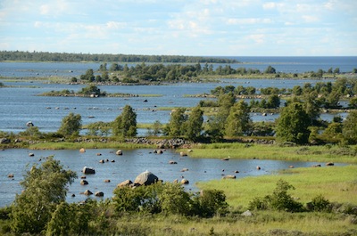
moraines that are so typical of this area.
The journey from Svedjehamn harbour, Björköby village is an experience in itself. At the Kvarken, the land is continuously rising (greetings from the Ice Age!) - amounting to about 8 mm per year. It may not sound like much, but the islands are slowly growing together and once open bays are closing in. Our guide Roland Wiik notes that after ten year's time the boat won't be able to follow the same route anymore.
I watch the narrow islets that have been forming here and there. The Baltic Sea is giving us a smooth ride. What a glorious day! It is very hard to imagine that the Kvarken is still going through the strange transformation process that began thousands of years ago, and that eventually it will lead to Finland and Sweden being joined by land at the Kvarken area. However, that may take as long as about 2000 years...
There used to more separate islands at Valsörarna islands but some of them have already grown together. As our boat approaches the jetty at Ebbskär harbour, two beautiful cranes take off from the shore. The tiny harbour is these days deserted; the Coast Guard station was closed in 2009.
Our guide Roland Wiik is proud to say that Finland's oldest and largest private nature reserve was established at Valsörarna islands already in 1934. The nature trail (2.8 km) begins right next to the old Coast Guard station.
The symbol painted on the wall of a nearby building is a remnant from the first lifeboat station established at Valsörarna in 1904. However, despite the Kvarken being such a tricky area to navigate in, there is no longer a lifeboat station on the island. Saving costs, yes; saving lives...?
A small viper hides quickly when our group approaches its resting place. The small red house was originally built here for the "lifesavers" but these days it serves bird-watchers as a biological station. There is an abundance of different birds in the islands.
For the first part of the trail the vegetation is very low, consisting mostly of cranberries and heather. However, the trees will very quickly take over the land unless the traditional archipelago methods are used: in many islands, people used to burn the ground once in about every 40-50 years (to enable new growth on more fertile soil) or let sheep roam the land, eating whatever they could find. Either of those helped in making the land provide you with more food, such as wild berries.
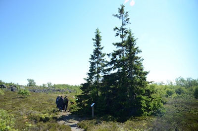
After a bunch of  birches and small aspens, we meet a group of fir trees. Our guide stops to show us that this is a family spruce.
A family tree? Yes indeed. The tallest spruce in the middle is Mummy, and her children, the baby spruces, have sprung up from the low-hanging branches that have first crawled on the ground and then started growing upwards. But they still haven't cut the cord with Mummy!
Further along, we take a side step to Käringsund which used to be a proper bay but over the years, as the land has risen, it is now a flada that is only linked to the sea by a narrow brook. As years go by and the connection is broken, it will eventually become a lake.
The rocky patches by the side of the nature trail indicate that the seashore used to be up there. The rowntree grows in the middle of some rocks that are laid out like a shelter for fishermen - which is what it used to be. Today, such shelters are made of logs. Wow, the rowntree is still in bloom although it is already July!
I walk up to the rocky monument which has a sad history. In March 1809, the Russian General Barclay de Tolly led his troops across the frozen Kvarken from Finland to Sweden and managed to conquer Umeå city, but was told to turn back. The trip was hard for his men in the freezing conditions and as a result, hundreds of the soldiers died on these islands. In 1930's the last remains of these soldiers were gathered under this pile of rocks.
We are now walking on a stone bridge that was built and used to connect the Ebbskär island with Storskär island - but that was back in the 19th century, during the construction work for the lighthouse... There is absolutely no water in sight anymore, and the two islands have grown together long ago.
Some wild white orchids grow among the low bushes. The forest type is once again changing. Oh no, I can hear more and more mosquitoes...
The grove feels like a mosquito heaven but I try to walk slowly and take in what I can of the absolutely beautiful surroundings. Waving my hands like mad, though. Go away, mosquitoes!
I breath in the gorgeous greens. It is as if it was spring again, the colours are simply magical. A paradise, except for our tiny friends that keep circling us for fresh blood.
Lunchtime! We are almost at the end of the tour, arriving at the bright red lighthouse and the former lighthouse keepers' dwellings. The original plan was to build the lighthouse at Ebbskär, where we just came from, but to build a lighthouse properly you need very solid ground, and this was nearest to finding a good foundation. Thus the road. I don't envy the workers who had to move the stuff here from the original building site on the other side of the islands.
Storskär lighthouse was completed in 1886 and the steel constructions were designed by no other than Henry-Lepaute engineering company in Paris, France. One of their next projects was a certain Eiffel tower in Paris.
Blades of cotton grass are swaying in the air, as if waving us goodbye. We walk to the shore to meet the boat and complete the nature trail feeling very happy. There is yet the boat ride to enjoy! And after this trip, if I happen to hear the shipping forecast on the Finnish radio, it will feel different because now I know exactly where these unique islands are and what they looked like in the summer of 2012. This is truly a place that will never look the same again!